Neural network and Remote Sensing
Due to the non-linearity and complexity of the measurements made by the color sensors ocean, and taking advantage of the gigantic data reduction technique offered by the deep neurons, machine learning or machine learning has proven to be a powerful tool for a wide range of tasks, including image recognition and natural language processing (LeCun et al., 2015) but also in the field of satellite remote sensing. In the paper "Modeling the Chlorophyll-a from Sea Surface Reflectance in West Africa by Deep Learning Methods: A Comparison of Multiple Algorithms" published in International Journal of Artificial Intelligence & Applications (IJAIA), November 2019, we develop a unique Deep Learning Neural Network model capable of relating marine reflectance to chlorophyll-a from any satellite sensor over West Africa. Marine reflectance data from the Ocean Colour project of the Climate Change Initiative (CCI). which produces long-term multi-sensor time series of satellite data on the ocean color, are used to implement several deep learning regressors with the help of Keras and sklearn bookstores. Linear models are a simple way to predict production using a linear function of the input characteristics.
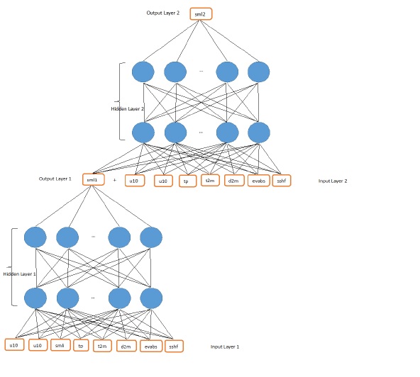
In the West African region, we also wanted to understand the dependence of climate variables on total column water vapor (TCWV). For this, we first used regular samples of data from the ERA-5 model - ECMWF (European Centre for Medium-Range Weather Forecasts). In the article "Deep Learning based Multiple Regression to Predict Total Column Water Vapor (TCWV) from Physical Parameters in West Africa by using Keras Library" published in November 2019 in International Journal of Data Mining & Knowledge Management Process (IJDKP), we apply multiple regression based on deep machine learning to establish possible correspondences between TCWV and climate-meteorological variables that could improve spatiotemporal prediction. In this study, using data from ERA-5, we predict TCWV. ERA-5 is the fifth generation of atmospheric reanalysis of the global climate by the ECMWF center. The meteorological reanalysis data are produced by combining measurements, observations and simulation data using data assimilation techniques, to arrive at the most accurate description of the realism of meteorological phenomena. We use a multiple regression algorithm based on deep learning using the Keras library to improve water vapor prediction total precipitation by parameters and variables such as mean sea surface pressure, total precipitation, total precipitation surface pressure, sea surface temperature, the U-100 zonal component of wind speed at 100 meters, the V-100 meridian component of the wind speed at 100 meters, the U-10 zonal component of the the V-10 meridian component of the wind speed at 10 meters, the temperature of the wind point at 10 meters, the temperature of the dew at 2 meters, temperature at 2 meters. The results obtained make it possible to build a predictor that models the TCWV with a mean absolute error equal to 3.60 kg/m2 and a determination coefficient R2 equal to 0.90. Thus, we see that the ERA5 re-analyses allow decision-makers, states, and companies and individuals to access and use more accurate information on land conditions. It is in the same vein that, given the global context of water scarcity, we have wanted to conduct a study to accurately predict soil moisture for rational use and management of this water in the West African part between 6°N-24°N and -17°W -34°W. In the article "Soil Moisture Prediction Model from ERA5-Land Parameters using a Deep Neural Networks", Science and Technology Publication (ScieTePress), ISBN: 978-989-8425-84-3, using the large amount of ERA5-Land data obtained in West Africa, we have set up a deep neural network to establish a soil moisture estimate for the first two layers and its temporal and spatial prediction. We are building a deep neural network model, called 2NNL2, which predicts soil moisture in Layer 1 (0-0.07 cm deep) and Layer 2 (0.07-). 0.28 cm deep) several days in advance. The ERA5-Land data used is composed of five meteorological data such as temperature at 2 meters (t2m), the dew point temperature at 2 meters (d2m), the total precipitation (tp), the zonal component U of the wind at 10 meters (u10) and the meridian component v of the wind at 10 meters (v10) ; two parameters related to soil properties such as bare soil evaporation (evabs) and sensible heat flux at the surface (sshf); and the initial soil moisture (smli). We use five models to predict soil moisture levels several days in advance. Model 1: The output data of Network 1 (sml1) is measured two (02) days after the input data. Network 2 (sml2) output is measured three (03) days after the input data and one (01) day after the input data. day after sml1. Model 2: The output data of network 1 (sml1) is measured three (03) days after the input data. The output data of network 2 (sml2) is measured four (04) days after the input data and one (1) day after the input data. (01) day after sml1. Model 3: The output data of Network 1 (sml1) is measured four (04) days after the input data. The output data of network 2 (sml2) is measured five (05) days after the input data and one (01) day after sml1. Model 4: Network 1 output (sml1) is measured five (05) days after the input data. The output data of network 2 (sml2) is measured six (06) days after the input data and one (01) day after sml1. Model 5: The output data of Network 1 (sml1) is measured six (06) days after the input data.
It is more accurate sometime to use deep learning for estimating environment parameters than others empirical methods